shawnee national park, shawnee national forest entrance fee, things to do in shawnee national forest, places to stay near shawnee national forest, directions to shawnee national forest, shawnee national forest wildlife, chicago to shawnee national forest, shawnee national forest dispersed camping, towns near shawnee national forest, hotels near shawnee national forest, Shawnee National Forest cabins with hot tubs
Shawnee National Forest
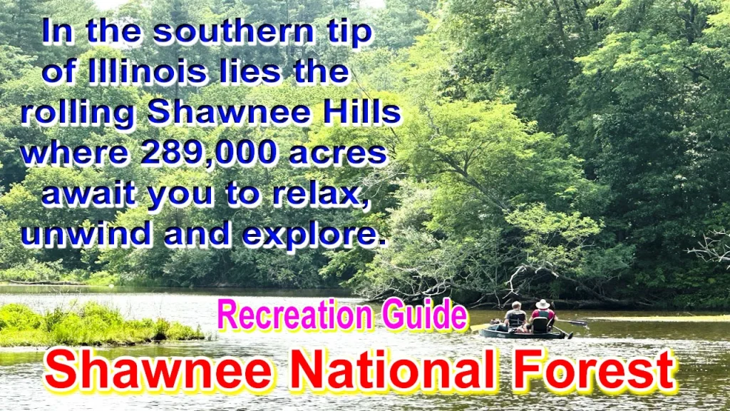
Spread over 289,000 acres, the Shawnee National Forest is located in southern Illinois between the Ohio and Mississippi rivers. It has stunningly beautiful oak-hickory forests, rich wetlands, lush valleys, razorback ranges and unique geological features. For recreationists there are miles of hiking, bicycling and horseback riding trails, kayaking, canoeing, established camping and scattered camping opportunities.
A rare convergence of six natural ecological zones results in a diversity of plant and animal species. With approximately 1 million people visiting annually, the forest serves as a haven for Americans living in urban areas; More than 30 US cities are within a six-hour drive.
Shawnee National Forest Dispersed Camping
Shawnee National Forest offers a variety of camping experiences, from primitive backpacking to developed campgrounds equipped with showers and electrical sites. Most campgrounds and picnic areas are located near lakes or areas of exceptional beauty. Hiking, fishing and sightseeing are just some of the recreational opportunities found nearby. Campsites are available on a first come, first served basis. Reservation is not accepted here. Campgrounds are generally open from April 1 through December 15, although there are exceptions.
Johnson Creek, Pounds Hollow and Lake Glendale Recreation Areas are located near the lakes. Oak Point Campground at Lake Glendale Recreation Area has electrical sites, showers and RV dump stations. Campgrounds that can accommodate RVs up to 40 feet are Johnson Creek Group Campground, Oak Point, Tower Rock, and Camp Cadiz. Pound Hollow Campground offers a camping loop with electric sites.
Apart from group sites, there is a maximum of two tents, two vehicles and eight people per site. The maximum duration of stay at the campsite is 14 days. Large group camping is available at the Lake Glendale Recreation Area, please contact the Lake Glendale Concessionaire. Horseback camping is permitted at Johnson Creek and Camp Cadiz Campgrounds.
The following rules apply at designated campgrounds:
Leaving your campsite unoccupied during the first night after the equipment is installed or for more than 24 hours thereafter is prohibited. Check out time is 2:00 PM. Parking and camping on the grass outside the designated campsite is prohibited. Keep campfires contained within the fire rings provided at each campsite. Cutting of living trees, shrubs and other vegetation is prohibited. Quiet hours are in effect from 10:00 p.m. Weapons, firearms, and fireworks must not be left in campgrounds or picnic areas until 6:00 a.m. Pets are welcome, but must be on a leash and are not allowed in designated swimming areas.
Shawnee National Forest Horse Riding & Camping
stock usage
Stock use is generally permitted in most areas of the Shawnee National Forest, with the following exceptions:
- Stock is not allowed in natural areas.
- Stock is not allowed on pedestrian routes only.
- Stock is not permitted in developed recreation areas, unless specifically authorized by instructions posted on the site. Under exception, stock is allowed at Camp Cadiz Campground and Johnson Creek Campground.
Special Information for Stock Use in Watersheds
Within the Lusk Creek, Upper Bay Creek, Big Grand Pierre Creek, and Eagle Creek watersheds, the rules governing stock use are different than in the rest of the Shawnee National Forest. The rules governing stock use in these four watersheds include the following:
- Stock is permitted only on designated equestrian trails, public roads, designated stock confinement areas, equestrian trail heads, and designated parking areas for equestrians. Authorized routes and areas for stock are identified on the Shawnee National Forest Hiker/Equestrian Trails Map.
- Stock is not permitted in developed recreation areas unless specifically authorized by instructions posted on the site. In these four watersheds, stock use is authorized on certain trails and trailheads in the Garden of the Gods (Backpackers Parking Lot, River to River Trail, Trail #108K, and the Garden of the Gods Hitching Rail just north of the Observation Trail parking lot). ,
- Stock is not allowed in Millstone Bluff.
- In the Lusk Creek Wilderness, stock users are not permitted to tie their stock on or along the “ride-through only trail” across Saltpeter Cave and then east along Lusk Creek near Natural Bridge, as identified on the trails map Has gone.
- Lusk Creek, Bay Creek and Garden of the Gods Wilderness areas are closed from December 1 through March 31. Additionally, during the months of April, May, September, October and November, the Lusk Creek Wilderness Stock would be closed for use whenever more than an inch of rain fell within a 24-hour period. This ban will last for at least a day. Current information on wilderness rain closures can be obtained by calling the trail hotline at (618) 658-1312.
- Group sizes are limited to no more than 10 people for all users in the Lusk Creek, Bay Creek and Garden of the Gods Wilderness areas. Where stock confinement areas are located in the wild, group size at these locations varies, but is limited by the number of tying points on the high lines there. The groups are told to stay out of sight and sound of each other. If encounters with other groups cause you to exceed these limits, please get out of sight and sound of each other as soon as possible.
- Camping with livestock is prohibited in the Lusk Creek, Bay Creek and Garden of the Gods Wilderness areas.
- The stock should not be tied within reach of a living tree. Will the stock be cross-tied, staggered or controlled
Where To Buy Northwest Forest Pass 2023 | Buy a All Forest Service Pass
Shawnee National Forest Hiking | Shawnee National Park
Shawnee National Forest has many miles of diverse hiking and backpacking trails, including a 160-mile river-to-river trail. Be extra careful during hunting season by wearing bright orange clothing. It’s a good idea to carry a compass and map. Forest streams do not meet drinking water safety standards. We recommend that you take your own drinking water with you. National forest ownership is linked with privately owned land. Respect the rights of private landowners by living on public land. Pedestrians should bow before horse riders. Going down the path and talking to the rider will help to avoid spooking their horse.
Shawnee National Forest Nature Viewing
Birding Opportunities
Southern Illinois features the inclusion of 4 distinct natural divisions: the Missouri Ozark Hills, the Mississippi River Bottomlands, the Shawnee Hills, and the Coastal Plain. Because of this, Shawnee provides a wide variety of habitats within a short distance of each other that contain exceptional bird diversity. In addition to habitat diversity, Shawnee National Forest is also located in the Mississippi Flyway, a prime location for viewing migrating birds.
We know that the Shawnee National Forest is home and host to more than 200 species of breeding and migratory birds, thanks to the citizen scientists who collect data for the annual local Christmas Bird Count, Spring Bird Count, and Breeding Bird Survey . A new citizen science project called eBird allows individuals to submit their observations throughout the year. We’d love your help to learn more about the birds who call this forest home, and those who pass through on their journeys north and south.
To do this, you can identify and count the birds you see, and submit your observations to an international citizen science project called eBirds. In addition to contributing important data to science, eBird allows you to keep track of your bird lists, explore maps and graphs, and share your sightings and join the eBird community! You can find full instructions and support for using eBird directly on their website.
Recommended Birding Sites
- South of Carbondale, IL
- Pomona Natural Bridge
- Cedar Lake Trails
- Oakwood Bottoms Interpretive Site
- LaRue Pine Hills Ecological Area
- Northwest of Carbondale, IL
- Kinkaid Lake Trail
- South of Marion, IL
- Panther Den Wilderness
- Lake of Egypt
- Dutchman Lake
- South of Harrisburg, IL
- Bell Smith Springs Natural Area
- Garden of the Gods
- Lake Glendale Recreation Area
- Jackson Falls
- Rim Rock Trail
How do I prepare for a visit to the Shawnee National Forest?
It’s always a good idea to plan for your trip in advance, including requesting necessary information and maps well in advance of your trip. For trip preparation details, including safety information, see our Forest Safety Information Brochure or contact us at 1-800-MY-WOODS.
How do I find my way to Shawnee? | Shawnee National Park
Click here to open the Shawnee National Forest Guide which is very useful. You can also request guides and other forest information by contacting the Shawnee Forest Mailroom. You can also call or visit any of the department’s offices in Harrisburg, Vienna or Jonesboro. Office hours are Monday through Friday, 8:00 AM to 4:30 PM CST. To contact the headquarters in Harrisburg, call the department at 1-800-MY-WOODS. Please consider requesting this information well in advance of your trip so that you can receive it in time.
How to Apply For Veterans’ Disability Compensation (with 2023 Toxic Exposure Update)
How do I find a recreation area, picnic site or campground?
Forest recreation areas, picnic sites and campgrounds have no physical address. So in that case you go to Driving Directions to Recreation Areas on Shawnee for directions to the various sites. You may also request a Shawnee National Forest Guide brochure by contacting one of the Department’s offices in Harrisburg, Vienna or Jonesboro. If you plan to visit the area outside of our regular office hours of 8:00 a.m. to 4:30 p.m. CST, please contact the department to obtain the necessary information and maps prior to your visit.
Where are the Shawnee National Forest Offices located in relation to recreation areas?
The headquarters office is located at 50 Highway 145 South, Harrisburg, IL 62946. This office is located on the east side of Shawnee and is the first building on the right when you leave Harrisburg and turn south on Route 145/34. It is approximately 22 miles north of the Garden of the Gods Recreation Area. You may contact this office by calling 1-618-253-7114 or 1- 800-MY-WOODS. The Hidden Springs-Vienna office is located at 602 North First Street, Vienna, IL 62995. This office is located on Route 45 just off I-24. It is approximately 15 miles west of the Lake Glendale Recreation Area.
You may contact this office by calling 1-618-658-2111. The Mississippi Bluffs – Jonesboro office is located at 521 North Main Street, Jonesboro, IL 62952. This office is located on the west side of Shawnee, just off Route 146. It is about 8 miles east of the Laru Pine Hills Research Natural Area. You may contact this office by calling 1-618-833-8576. Office hours are Monday through Friday, 8:00am to 4:30pm CST.
Are there entrance or day-use fees charged at the Shawnee recreation areas?
No. There are fees associated with the concessioner managed Lake Glendale Recreation Area.
Can I reserve a picnic shelter or any other area on the Shawnee National Forest?
No. The Shawnee does not reserve – All picnic shelters and other recreation areas are first-come, first-serve.
How do I obtain a detailed map of the Shawnee?
Maps are available for purchase at all Department offices located in Harrisburg, Vienna and Jonesboro. You can also visit the Department’s Map Order Form to print a copy of the Shawnee National Forest Map Order Form. Please order your maps in advance so that you can receive them before your trip. If you need assistance, please contact the department at 1-800-MY-WOODS.
How To Apply For Food Stamps (SNAP benefits) | Income Limit Eligibility
I-90 Form PDF 2023 Download | How to Fill Form I-90
How do I obtain a trail map of a specific area of the Forest?
Shawnee offers a detailed Synthetic Trails Designation Project Map for sale for $10.00 at the department’s offices in Harrisburg and Vienna. This map includes four watersheds: Lusk Creek, Upper Bay Creek, Eagle Creek, and Big Grand Pierre Creek. Please note that this map covers the eastern half of the forest (the area from Garden of the Gods to Lusk Creek).
Do I need to make reservations to camp on the Shawnee?
No, Shawnee does not take reservations; All campgrounds are first come, first served. When you arrive at the developed campground entrance, please follow the directions at the fee station. To learn more about the Shawnee-developed campground, click here: Shawnee National Forest Recreation Area. Leave no trace policy applies to all visits to Shawnee.
Does the Shawnee National Forest have cabins?
No. To find out more information about cabins near Shawnee National Forest, visit Southern Illinois Tourism or call 1-800-248-4373.
Can I bring my dog on my visit to the Shawnee?
Yes. Dogs are welcome in Shawnee National Forest; However, they must be leashed or controlled in developed recreation areas such as campgrounds, picnic areas, and developed trails.
What is the difference between developed and scattered camping in the woods?
Developed Campgrounds: All campgrounds are first come, first served, so there is no booking of sites. There is a fee at these campgrounds that provide facilities such as picnic tables, lantern posts, grills, parking lots, potable drinking water and toilets. There is also a dustbin nearby for your use. Camping is permitted for a maximum of 14 nights at one campsite.
Some of these campgrounds are closed seasonally; Please see our entertainment site index for more information. For specific regulations, visit Developed Campground Regulations for details on developed campground camping. It’s also a good idea to leave your location and expected date of return with someone at home.
Dispersed Camping: Dispersed camping at Shawnee is free and does not have any facilities. For specific regulations, visit the Dispersed Camping Regulations for Dispersed Camping Regulations. No permit is required. It’s also a good idea to leave your location and expected date of return with someone at home. The Leave No Trace policy applies to all visits to Shawnee.
How do I obtain firewood for my campsite?
Firewood should be obtained from local sources only. If you use wood near your campsite, you should only use dead and fallen wood. This will help reduce the spread of non-native insects, which can kill trees in large numbers.
How big is the Shawnee National Forest? Where is it located?
The Shawnee National Forest covers approximately 287,000 acres. It is located in the southern tip of Illinois between the Ohio and Mississippi Rivers. Click here to open our Shawnee National Forest guide, which includes a map of the forest.
Are America the Beautiful or Federal Recreation Passes available at your offices?
Yes. Senior, admission and annual passes are available during regular office hours. If you have any questions about the program, you can contact the department at 1-800-MY-WOODS. For additional information on the Federal Recreation Pass program, visit a USGS store or contact USGS at 1-888-ASK-USGS (1-888-275-8747).
I want to hunt or fish on the Shawnee? What regulations apply?
Hunting: Illinois state regulations apply to the Shawnee as well as some additional regulations specific to the forest. Visit Hunting the Shawnee National Forest for forest hunting information. Visit the Illinois Department of Natural Resources to access state regulations or to view their Hunting and Trapping Digest. Leave no trace policy applies to all visits to Shawnee.
Fishing: Fishing on Shawnee is free for people 15 and under. An Illinois fishing license is required for anyone over the age of 15. To access state regulations and information on how to purchase your fishing license, visit the Illinois Department of Natural Resources or contact IDNR at 1-217-782-6302.
GPS Coordinates of Recreation Areas PDF Download
Shawnee National Forest Headquarters | Shawnee National Park
50 Hwy 145 South
Harrisburg, IL 62946
(618) 253-7114 or
1-800-699-6637
Hidden Springs Ranger District | Shawnee National Park
602 N. First Street
Route 45 North
Vienna, Illinois 62995
(618) 658-2111
Mississippi Bluffs Ranger District
521 N. Main Street
Jonesboro, Illinois 62952
(618) 833-8576
If You Get Lost in the Shawnee National Forest
If you do become lost your most important tool is keeping a positive mental attitude.
Stop:
As soon as you realize you might be lost: Stop, be calm, be still. Panic is your biggest enemy.
Think:
Think in your mind how you got here. What landmarks should you be able to see? Don’t move at all unless you have a specific reason to move.
Inspection:
- Get out your compass and determine the direction based on where you are standing. Don’t walk aimlessly.
- If you’re on a path, stay on it. All routes are marked with signs (where intersections meet) and diamond blazers or markers. However, signs are sometimes vandalized or stolen.
- As a last resort, follow a drainage ditch or stream on a slope. This is often a rough path but can lead to a footpath or road. Again, this can be very dangerous.
Plan:
- Based on your thinking and observation, come up with some possible plans, consider them and then act on any one of them.
- If you are not too sure about the route, it is always better to stop there.
- If it’s night, you’re injured, or you’re close to exhaustion, stay where you are.
Shawnee National Forest Self-rescue tips | Shawnee National Park
If after careful planning and consideration you decide that you should try to rescue yourself, here are some tips to remember:
- Stop and rest when you start to feel tired. Don’t wait until you are exhausted.
- Your body can’t hike hard and digest food at the same time. Rest in the shade for at least 30 minutes when you stop to eat. If you are still tired after 30 minutes, continue to rest.
- Make sure to drink enough water to avoid dehydration. Symptoms of dehydration could include thirst; dry/sticky mouth; not urinating very much or dark yellow urine; dry, cool skin; headache; muscle cramps.
- Stop and fix small problems while they are still small. If you ignore your body and keep pushing, the pain or illness will only get worse and make recovery more difficult.
- Avoid hiking between 10 a.m. and 4 p.m. on hot days. If you are on a trail between those hours, find a shady spot and stay there until the temperature cools down. Adjust your hiking pace to one you can comfortably maintain and rest when you feel the need.
Remember: You are responsible for your own safety and for the safety of those around you.
Make Plans to Visit Shawnee National Forest
directions to shawnee national forest : Hiking in the Wilderness Your best tool for survival if you get lost outside is your advanced planning skills. You must expect the unexpected and plan accordingly. Even if you’re only going out for a few hours, pack enough essentials so you can stay hydrated, energized, and prepared for any type of weather.
Your essentials should include at least:
- More than enough food and water for your planned activity.
- A compass you know how to use. Maybe you want a GPS device, but sometimes they can’t get a signal or the battery is dead. Cell phones may also not work due to lack of signal.
- suitable map. Study the terrain and your planned route. Know where you are going and how you will return.
- sturdy hiking shoes, clothing you’ll need depending on weather conditions
- and extra socks in case what you’re wearing gets wet.
- A blanket, torch, matches placed in a water-resistant container, and other items that will help you survive the night if necessary.
- Contact the local ranger district or forest office for special warnings, such as area fires, bear sightings, flooding, trail or road closures, etc.
It’s also important that once you have planned your outing, tell someone. Give them exact details of where you are going, the trail you plan to follow, when you will return, the vehicle you are driving (and where you plan to park) and how many people will go with you – don’t go alone.
National Overview Maps | directions to shawnee national forest
The next generation interactive visitor map has been released by the department. Visitor Maps 2.0 provides the public with an online view of Forest Service roads, trails, recreation sites, wilderness areas, and wild and scenic rivers. “A Guide to Your National Forests” is a free brochure that shows the locations of national forests and grasslands along with contact information.
Shawnee National Forest Guide PDF Download
Forest Visitor Maps, National Forest Atlas, and Wilderness Maps
This map of the US Available for purchase at Geological Survey stores, many Forest Service offices, and other retail outlets. Several forest visitor maps are also available for purchase as geo-referenced PDFs on Avenza, for use on mobile devices.
- Forest visitor maps for each national forest and grassland provide forest-wide information on attractions, facilities, services and opportunities.
- National Forest Atlases are full color atlases, include 8.5-inch x 11-inch topographic quadrangle maps at 1 inch to mile scale and are available for many California forests.
- Wilderness maps are topographic maps that depict natural features such as mountains, valleys, plains, lakes, rivers, and vegetation, using contour lines showing gain or loss in elevation. Each map covers all or part of a wilderness area and the scale is typically 1 inch per mile (1:63,360).
Shawnee National Forest Rules and Restrictions by Topic or Location
Occupancy & Use – Includes:
- Being in Areas or Sites Posted “Closed”
- Camping
- Public Nudity
- Swimming Areas and Beaches
- Food & Beverage Glass Containers (Bell Smith Springs)
- Disposable Food or Beverage Containers or Packages (Garden of the Gods Observation Trail)
- Possession of Alcoholic Beverages in violation of State of Illinois Law
- Possession of Cannabis
- Fireworks
- Spark Arrestor Device
It is the visitor’s responsibility to be knowledgeable about the rules and regulations of the Shawnee National Forest and the activity in which they are participating. Campgrounds, picnic areas and trailhead bulletin boards are some of the places where rules and regulations are posted, although they may not contain a complete list for various reasons. If you have questions about what is permitted on National Forest land, please contact the Shawnee National Forest Office. The Forest Supervisor has the authority to lay down and lay down more specific rules, these are known as “Forest Orders”.